
UPDATE (5:23 p.m.) — The tornado warning has been allowed to expire for Jerauld County. Western Sanborn County will be clear as of 5:30 p.m. as the storm has weakened. The warning for northern Sanborn and southeastern Beadle Counties is also going to expire at 5:30 p.m. as the storm has moved through the area affected. There is still a potential tornado near Huron.
UPDATE (5:10 p.m.) — A new severe thunderstorm warning now covers the northern half of Davison County and Hanson County, including the city of Mitchell. The warning is in effect until 6:00. NWS expects the storms to be in Mitchell at 5:10, along with Artesian and Loomis. It will continue east at 35 mph until it runs into Fedora around 5:20 p.m. and Roswell at 5:25. The storms have up to 90 mph winds near Artesian and up to quarter size hail. The NWS has classified these as extremely destructive thunderstorms.
UPDATE (4:51 p.m.) — A severe thunderstorm warning has been added to extreme northwestern Davison County, along with Sanborn County, south central Beadle County, northern Aurora County, and Jerauld County. The National Weather Service says the line of storms was identified at 4:28 p.m. It stretches from seven miles north of Wessington Springs to seven miles southwest of Lane and over to about eight miles northwest of Plankinton. The center of the line has a confirmed tornado that ran through Woonsocket at about 4:40 p.m. The tornado warning for western Sanborn County, northeastern Aurora County, and southeastern Jerauld County is in effect until 5:30 p.m.
At 4:45 p.m., the NWS identified another severe thunderstorm capable of creating a tornado in central Beadle County over Alpena. It is moving east at 40 mph. Another cell that is potentially tornadic is southwest of Huron by Virgil, heading towards the city at 20 mph. The tornado is expected to hit Huron at 4:55 p.m.
The thunderstorms are packing a punch with 70 mile per hour wind gusts and quarter size hail. Expect considerable tree damage, plus problems for mobile homes, roofs of single-family homes and apartment complexes, and any sheds or outbuildings that are in the path of these storms. They are moving due east at 40 miles per hour.
UPDATE (4:15 p.m.) — A tornado warning has been extended until 4:30 p.m. for Beadle and Jerauld Counties. The tornado is moving northeast at 10 mph. On top of the dangerous winds and threat of flying debris, the storm features half dollar size hail. The tornado is southwest of Huron over rural territory at the moment.
Severe thunderstorms are coalescing into a line with warnings now in effect starting in Brule County near Chamberlain and bowing across northwestern Aurora County, eastern Buffalo County, most of Jerauld County, southern Hand County, and southwestern Beadle County. The storms are racing northeast at 30 miles per hour and heading towards Wessington Springs. The thunderstorms feature 70 mile per hour wind gusts and quarter size hail.
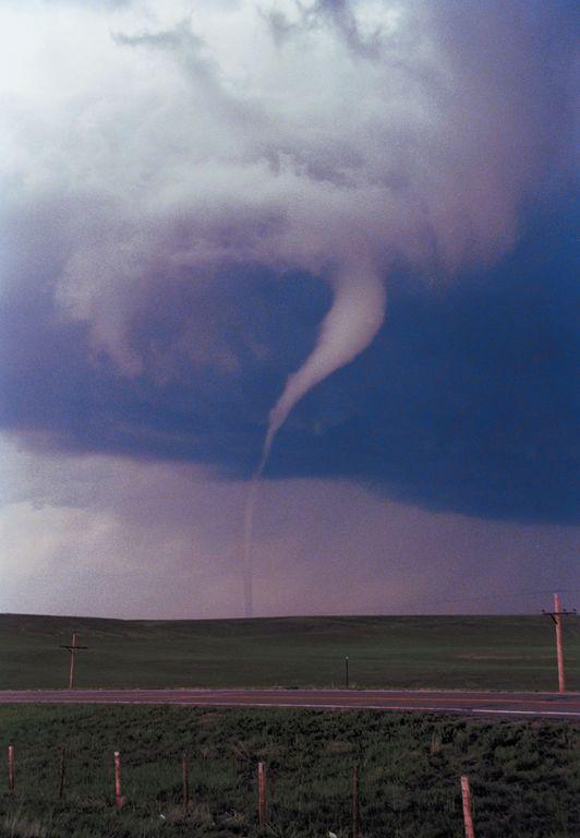
MITCHELL, SD (Mitchell Now) — A tornado has been confirmed in Buffalo County, near the Jerauld County line.
The National Weather Service expects the storm to cross into rural Jerauld County shortly. A tornado warning for Jerauld is in effect until 4:00 p.m. The storm is moving northeast and features golf ball size hail in addition to the twister.
Anyone in the path of the storm is urged to seek shelter immediately. Flying debris will be a danger to those outside. Mobile homes will likely be damaged or destroyed as will windows and roofs on homes. Vehicles are not safe, either. Those inside a home need to get to a basement or interior room on the ground floor.
Another threat in the area is flooding taking place on the Missouri River and all of the creeks, tributaries, and feeder rivers that pour into it. The National Weather Service says the flooding in northwestern Buffalo County, southeastern Hughes County, southwestern Hyde County, northern Lyman County, and southeastern Stanley County is already underway, or is imminent.
Several popular outdoor spots like Lake Sharp and Tailrace Recreation Area near Fort Thompson, West Bend Recreation Area, and Joe Creek Recreation Area are seeing water levels rise to dangerous levels.